Luna B. Leopold, the foremost American student of rivers and the landscapes they create, died February 23 at age 90. I never met him, but I’ve been a follower and a fan of his work, which I first encountered in 1966, when Scientific American published an article titled “River Meanders,” by Leopold and W. B. Langbein. Not many magazine articles stay with you for 40 years; this one was unforgettable. Before I read the article, landform features such as the sinuous path of a stream had seemed quite arbitrary or accidental—or they would have seemed so if I had ever bothered to think about them at all. Now they were suddenly revealed to have an explanation, an internal logic. With a bit of physics and mathematics and imagination, you could follow the steps of the dance by which rivers carve the land and the land guides the rivers.
Many years later I caught up with Leopold’s major textbook, Fluvial Processes in Geomorphology (co-authored with M. Gordon Wolman and John P. Miller, published in 1964 by W. H. Freeman). This is a much more engaging and accessible work than the title might suggest, and I can recommend it without reservation as summer-vacation reading, especially if you’re going to spend your vacation in a fluvial landscape—perhaps kayaking the Colorado. The book begins with a chapter composed almost entirely of questions provoked by simply looking at the land. Why do the Sandia Mountains in New Mexico rise abruptly and steeply on their west front but slope more gradually to the east? How did the Susquehanna River in Pennsylvania carve a channel straight through Kittatinny Mountain, Blue Mountain and Tuscarora Mountain, whereas lesser streams flow parallel to these ridges? How did ancient beaches on the coast of California wind up stranded 30 or 40 feet above sea level? In 1964 Leopold and his colleagues didn’t yet have answers for all these questions, but they did have a methodology for approaching them, as well as faith that the forces shaping the surface of the earth were something we could ultimately expect to understand.
The methodology was largely mathematical, and it’s interesting that Leopold, Wolman and Miller felt it necessary to apologize for that. “We are aware that the feelings of professional geomorphologists about numbers, graphs, and formulas range from acceptance and enthusiasm to bewiderment and forthright hostility. We have not gone out of our way to be mathematical, but whenever we felt that mathematics contributed either clarity or brevity to the discussion, it has been used.”
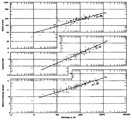
A notable early success of Leopold’s quantitative method was his discovery that the shape of a river channel and the flow of water through it can be understood through a set of simple power laws. At any given point along the course of a river, the width and the depth of the channel and the velocity of the water are each proportional to some power of the total quantity of water passing that point per unit time. For most rivers, the total volume increases steadily downstream; hence the width, the depth and the velocity must all increase monotonically as a river flows from its headwaters to its mouth. When this finding was first published (in a 1953 paper written by Leopold and Thomas Maddock, Jr.) it was surprising and controversial. Everyone knew that rivers get wider downstream, but the common impression was that they also get slower (because the landscape is generally flatter), and in most cases shallower (because of sediment buildup). Leopold and his colleagues made extensive measurements along some 20 rivers and showed that it just isn’t so. Width, depth and speed all increase steadily in the downstream direction. (The graphs below are for the Powder River at Locate, Montana. Straight lines plotted on a log-log scale are the telltale mark of a power law.)
Leopold’s explanation of river meandering also came as a surprise to many people. One might guess that anything falling from a height—including water flowing from the mountains to the sea—would seek out the line of steepest descent, or in other words the shortest path to the bottom. But a meandering river is obviously not following the shortest route to the sea. In some cases the length of the river is four or five times that of a direct route.
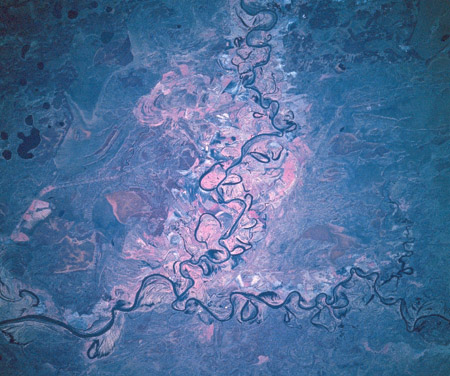
The image at the top of this article, made from the Space Shuttle Endeavour in 1994, shows the elaborate meanders of the Tobol and Tavda rivers in the West Siberian Plain. Why do rivers adopt (or create) such sinuous channels? The key to understanding Leopold’s answer to this question is the curvature of the path—a measure of how sharply it twists and turns. Assuming the path is reasonably smooth, it’s possible to measure the curvature at each point along a river’s course and to calculate a total curvature: the sum (or the integral) of the curvatures measured at all points along the path. Actually, the quantity of greatest interest is the sum of the squares of all the measured curvatures. Leopold found that for any given total channel length, the favored route is the one that minimizes the total squared curvature. In other words, the river tries to distribute its “budget” of curvature as evenly as possible all along its course, avoiding sharp bends where the square of the curvature would be very large. If such a sharp bend should ever develop, its banks would be rapidly eroded, restoring a minimum-total-curvature configuration.
I am fascinated by the way that Leopold and his colleagues happened upon this least-curvature principle. In the 1966 Scientific American article Leopold and Langbein write:
We first recognized the principal characteristics of the actual curve traced out by a typical river meander in the course of a mathematical analysis aimed at generating meander-like curves by means of “random walk” techniques…. In our random-walk study one of the constraints we adopted was that the path was to begin at some point A and end at some other point B in a given number of steps. In other words, the end points and the length of the path were fixed but the path itself was “free.”
The mathematics involved in finding the average, or most probable, path taken by a random walk of fixed length had been worked out in 1951 by Hermann von Schelling of the General Electric Company. The exact solution is expressed by an elliptic integral, but in our case a sufficiently accurate approximation states that the most probable geometry for a river is one in which the angular direction of the channel at any point with respect to the mean down-valley direction is a sine function of the distance measured along the channel.
Note that the path itself is not a sine wave; it is a curve generated by letting the direction vector vary sinusoidally as one moves along the length of the path. (Leopold calls it a “sine-generated curve.”)
There’s more to this story than I can tell here. If the goal is to minimize the total squared curvature of the path, that’s easy enough to do: Just draw a straight line from A to B. This suggests again that the line of steepest descent ought to be the favored route for a river. The reason for lengthening the path and then bending it into a sinuous curve is not fully explained in the Scientific American article, but Leopold and Langbein discuss it in a 1962 paper titled “The Concept of Entropy in Landscape Evolution.” Here they also give details about some remarkable early experiments in computer simulations of river action.
Leopold transformed the study of landscapes by insisting on quantitative methods, but he was certainly not just a numbers guy. Luna Leopold was the son of Aldo Leopold, one of the founders and heroes of the conservation movement in the U.S. It was Luna who assembled and edited his father’s essays, which were published posthumously in 1948 as A Sand County Almanac. Luna Leopold himself later became a passionate advocate for environmental preservation, entering into the controversies over the Alaska pipeline and a proposal to build an airport in the Florida Everglades.
Leopold studied civil engineering and meteorology before taking a Ph.D. in geology at Harvard. He had a long career at the U.S. Geological Survey, serving as Chief Hydrologist for a decade. During his years in Washington he continued doing field work by setting up gaging stations on Watts Branch, a stream that flows into the city from the eastern Maryland suburbs, joining the Anacostia River a few miles from the Capitol. In a 1994 book, A View of the River, Leopold urged amateurs in “backyard hydrology” to do the same with any nearby stream, and he offered some practical advice: “The easiest way to measure velocity is by floats, and the best float is an orange peel. It has just the right specific gravity to float nicely at the surface, it is brightly colored and thus easily seen, and it is readily available.”
After leaving the Geological Survey in 1972, Leopold taught at the University of California, Berkeley. He was still actively working in the weeks before his death. In an obituary for the Washington Post Patricia Sullivan writes:
Well known for his scientific fieldwork, he also made bows and arrows, hunted and fished, rode horses, composed piano and guitar music, danced, flew planes, painted landscapes, wrote poetry, bound books, acted on stage, built furniture, claimed to cook strawberry shortcake in a camp Dutch oven and told campfire stories. He floated on a raft through the Grand Canyon to measure the depth of the Colorado River.
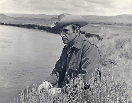
The portrait below (courtesy University of California, Berkeley) shows him at work on the East Fork River near Boulder, Wyoming, circa 1974, “attired in his typical Stetson, Filson cruiser coat and gloves.” When we make the movie of his life, we’re going to have to bring back Gary Cooper.
One further note: The Department of Earth and Planetary Science at Berkeley has set up a web site, The Virtual Luna Leopold Project, that lists 182 of Leopold’s publications and provides PDF copies of more than 100 of them, including all the articles and papers mentioned above, and also an excellent American Scientist article from 1962, titled simply “Rivers.”
Brian,
Luna Leopold led a full and inspring life. Having lived in New Mexico for 20 years and hiked extensively through the Gila Wilderness (I am now in Colorado) I feel an affinity and connection to both Leopolds. Thanks for the clearly (as usual) written profile of Luna Leopold and summary of his work. We are all better off that he and his father have graced this planet.
I’ve followed your writing for many years now and was pleased to see that you started this blog. I like the tone and content.
Pingback: bit-player » Blog Archive » Setting the river straight